Imaging beneath volcanics in the West of the Shetlands of the Atlantic Margin
 | |
| Series | Investigations in Geophysics |
|---|---|
| Author | Öz Yilmaz |
| DOI | http://dx.doi.org/10.1190/1.9781560801580 |
| ISBN | ISBN 978-1-56080-094-1 |
| Store | SEG Online Store |
The fourth 2-D case study for structural inversion is from the West of Shetlands of the Atlantic Margin. This case study deals with earth modeling and imaging beneath volcanics. Shown in Figure 10.4-1 is the CMP-stacked section in two parts. The stratigraphic column comprises shallow depositional sequences that are bounded at the base by a major unconformity (event A). Below the unconformity, is a volcanic layer (event B) with varying thickness. The exploration objective is the potential structural high below 2 s at midpoint location 3440 and the faulted zone below 3.5 s between midpoints 440-1240. Water-bottom and peg-leg multiples associated with the unconformity were largely attenuated using the Radon transform technique (the radon transform) before prestack depth migration. Poststack time migration yields an image of the subsurface that falls short of being acceptable for interpretation within the zone of interest below the unconformity (Figure 10.4-2). To obtain an improved image of this deeper zone, we shall perform earth modeling and imaging in depth. The procedure for earth modeling includes coherency inversion combined with normal-incidence depth conversion applied within the shallow depositional sequences (the overburden), and prestack depth migration and image-gather analysis applied within the zone below the unconformity (the substratum).
-
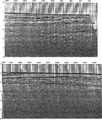 Figure 10.4-1 The West of Shetlands line: CMP stack in two parts. Event A corresponds to a major unconformity and event B corresponds to the top of the volcanic layer. (Data courtesy BP Exploration and Production.)
 -
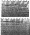 Figure 10.4-2 The West of Shetlands line: poststack time-migrated CMP stack.


See also
- Imaging beneath irregular water bottom in the Northwest Shelf of Australia
- Imaging beneath shallow gas anomalies in the Gulf of Thailand
- Earth modeling and imaging in depth
External links
| find literature about Imaging beneath volcanics in the West of the Shetlands of the Atlantic Margin |